Recently, Google released satellite images taken in Porto Alegre and Canoas, both in Rio Grande do Sul, which show the chaos after the rain, resulting in flooding, which left many homeless, in addition to obviously losing their belongings and some of these people missing.
The visualization is only available for Google Earth Pro (disable 3D before viewing). Therefore, I leave some coordinates for you to view.
1 – Beira Rio Stadium
30°03’54.53″S 51°14’06.36″W
2 – Firefighters, police and army tents to shelter victims rescued from the flood. There were also tents here where journalists followed the rescues.
30°02’10.22″S 51°14’27.85″W
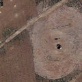
3 – ‘Cidade Baixa’ region, Porto Alegre flooded
30°02’43.10″S 51°13’26.52″W
4 – Neighborhood of the city of Canoas, near Porto Alegre completely flooded
29°57’33.72″S 51°11’16.12″W
5 – Pavão Island and archipelago flooded, and part of the bridge connecting these islands is also partially flooded.
29°59’38.50″S 51°13’6.85″W
Although the population of Rio Grande do Sul is returning to its normal routine, many still need help to restart their lives. Do your part!
Similar Street View images
 S.O.S Rio Grande do Sul 🇧🇷 • Streetviewfun
 Night in Pelotas, Rio Grande do Sul 🌃
 Weird Glitch in South Brazil
 Red Google Car in Rio De Janeiro
 Rio de Janeiro By Night🌃
There’s something about this place that Google doesn’t want to show us
Rio de Janeiro By Night🌃
There’s something about this place that Google doesn’t want to show us
 The “Human Eye” in desktop Google Earth 4/2019 shows it’s a water tank.
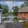 Flooding in Rochester NY
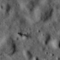 Satellite image of the Moon proves with 100% certainty that there is life beyond Earth